Goodbye to red tape: ADE SaaS is the new cemetery management software for NeMeA Sistemi
In the public sector, efficiency and transparency are top priorities, and this drive for modernisation also extends to complex and sensitive sectors such as the cemetery management. ‘NeMeA Sistemi’ takes centre stage with ADE, a SaaS (Software as a Service) solution, a cutting-edge solution that goes beyond traditional paper-based management, offering local authorities a single system that combines geographical precision with administrative accuracy.
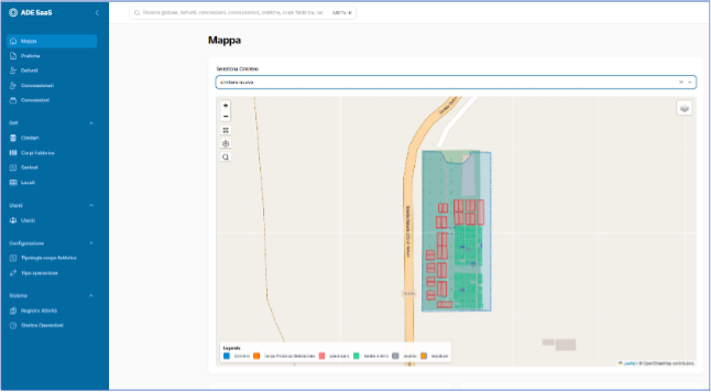
ADE SaaS It is a comprehensive cemetery management software, designed to digitise and streamline the entire administrative and spatial lifecycle of concessions. The system primarily addresses the need for geolocation: thanks to the integrated GIS platform, the operator can view real-time floor plans of cemeteries, burial niches and graves, linking the physical location of the recorded elements (niche blocks, family graves, ground-level graves, etc.) to all the digital documentation, including photographs and drawings. At the same time, the system acts as an operational hub that records the complete and legally compliant history of each deceased person. It supports the entire process, from the registration of identification details to the allocation of available burial plots, right through to the traceability of every movement, including transfers from the burial ground to a burial niche.
The integration of these features ensures the intuitive management of concession contracts and the compliance with the Mortuary Regulations, providing the necessary controls to ensure compliance. In summary, ADE SaaS transforms data into strategic information: it simplifies operational workflows, ensures regulatory compliance (through the automatic generation of official records) and provides detailed analyses of occupancy and facility performance, supporting the local authority’s strategic planning and enabling immediate tracking of deadlines and authorisations.
The new frontiers of ADE SaaS
The software’s new features focus on integrating map navigation with the viewing of personal and administrative data, streamlining access to and editing of information relating to cemeteries, the deceased and burial niches.
Search and view on map:
Navigation and data viewing are carried out by interacting directly with a map. The ‘Search on map’ function, which can be activated via the magnifying glass icon, sorts the results by type (deceased persons, burial niches, building blocks, concessions) and displays the total numbers. Selecting a category, such as the deceased, brings up a list and advanced filters to further refine the search (e.g. the deceased with an allocated burial niche).
Details and management:
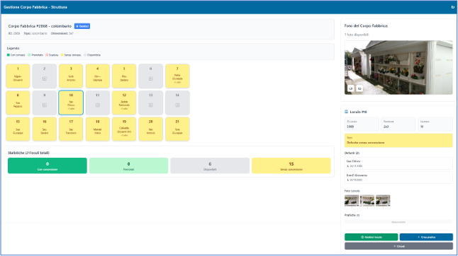
When you select a name from the list, a pop-up appears showing the personal details and the exact location (niche, building, cemetery). The ‘Manage Deceased’ command takes you to the building’s management section. From here, the ‘Manage Burial Niche’ and ‘Create Record’ options allow you, respectively, to view and edit the details of the burial niche (including status, location, photos and details of the deceased), or to access the form for creating a new record.
Text lists:
You can always use the side navigation panel to access comprehensive, filterable text-based lists relating to all managed entities: cases, concessions, deceased persons, concession holders, cemeteries, building complexes, sections and burial niches.
The evolution of ADE SaaS is the revolution that is bringing cemetery management into the digital age, guaranteeing local authorities and operators unprecedented transparency and control!